My trip to the Sport-Touring.Net 2003 National, in Custer, South Dakota.
You should read Part I first.
Part II. From SLC and to Minnesota
I arrived at the BMW dealership at 8:00am localtime, even though I knew
they wouldn't open until 9. That was fine, I wanted to have the time to
let the bike cool down so they could get started on it as soon as they
opened; it needed it's 18000 mile service, annual service, and a new rear
tire, and I still wanted to get part of the way into Wyoming before
calling it a day.
I pulled out my camp chair and read until 9am when they opened. The
guy who checked me in asked, "Where are you from" and I told him.
Unimpressed, he said "We've been getting lots of people from Florida
lately" -- what, are we lepers or something??
At any rate, they took the bike in, and got started on it while I
made myself comfortable in their visitors lounge. Now, if you're a
beemer rider and you're near SLC, you
really need to check this place out. Their visitor lounge has it all,
every single map you can get your hands
on, espresso machine, and internet
kiosks. I spent most of the morning sending
email to a few friends, as well as composing and posting Part I
of this report to a few web-boards
(note: I've revised Part I after reviewing my journal for the trip,
and included route numbers and daily mileage for the curious).
By 1:30pm localtime my bike was ready and I was on the road. Although
I really wanted to avoid the
slab as much as possible, I knew that there was no other way to make
decent time into Wyoming, so I reluctantly headed towards I-15. I took
I-15 south to I-80, then headed East into Wyoming (Land of Wind Tunnels).
Unlike New Mexico, Colorado, and Utah, the rock formations which
framed the road in south-western Wyoming were not red. Instead they
were a greenish-blue, as if they were loaded with copper ore. The
roads were apparently made of the same rock becaue the asphalt on the
interstate had a bluish tint to it. The contrast between the roads and
the surrounding countryside produced an eery image when viewed through
polarized lenses.
I continued on I-80 to Rock Springs, exit 104, where I headed
north on 191. The wind was howling coming from the west, and I rode
at a serious lean. A few miles on 191 and I came across a lone
rider on an ST-1100 with
Tennessee plates. I
waved as I passed him, and he decided to keep up. We rode at a rather
spirited pace
along 191, the wind causing us to work the left side of our tires pretty
well, as we raced (not figuratively) along the prairie.
We stopped at a park in the town of Eden, and chatted for a bit. His
name was Robert Lee, and he's from Memphis; but I doubt he's named after
the famous general from the
War of Northern Aggression. He was on his own solo trip and was
heading on 191 into Yellowstone. I
told him about the national,
and invited him on the trip -- offering to give him Josh's meal ticket
since Josh was a no-show.
He thanked me, but said he always wanted to visit Yellowstone. We talked
for about 20 or 30 more minutes, as if we were two solitary travelers
exchanging news from some long
forgotten time, before finally heading our seperate ways.
I veered east on WY-28 and headed toward Lander. The
wind in Wyoming
was howling now, and I noticed that it was such a persistent entity
that the tops of many of the surrounding hills were scrubbed clean as
if they were bones in an acid bath. The grass could not establish a
foothold in the places where the wind continually tore at them.
In Lander I hopped on 789 east towards Riverton. Of course, I ran into
that persistent thorn in my side, 'road work ahead,' on 789. There
was a five mile stretch where the road was nothing but dirt and gravel, and
several other places the road was one-laned.
I stopped in Riverton for dinner,
then took 26 north into Shoshoni. On 26 I encountered the
most unique single-laned
road -- it was completely self-serve. A light stopped one side of traffic
for two minutes while it let the other side travel. How odd,
but if it works for them...
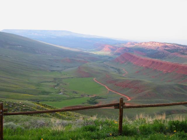
In Shoshoni I hopped on 20. While on 20 I passed "Red Canyon"
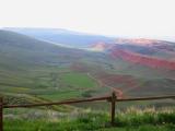 which was stunning. Beautiful red hills with lush greenery everywhere.
The contrast between the orange and green was very pretty.
which was stunning. Beautiful red hills with lush greenery everywhere.
The contrast between the orange and green was very pretty.
Continuing on 20, I eventually came into Boysen State Park and Wind
River Canyon. They had road-side camping for $12, so I went ahead and
pitched my tent. A valuable lesson was learned, camping in a place
with the word "Wind" in the name can be trying; even with my ear plugs
in, I still thought I was stuck in a hurricane all night long. I'm
sure Lewis and Clark didn't have it so rough when they came through
here..
Total miles: 383/3149
Wednesday, June 4th
I woke up bright and early and broke camp in a
hurry, mostly to keep everything in my campsite from blowing away. I
headed north on US-20 into the town of Thermopolis, home of the worlds
largest warm mineral spring.
After taking a few photos, I continued on 20 into the town of Worland,
where I grabbed a quick breakfast. It looked like it might rain on me,
which would have sucked, so I dragged out the rain gear and prepared for
the worst.
In Worland I hopped on US-16 and followed into Buffalo. If you're ever
in Wyoming, you MUST take this route. Heading east, it takes you into
Ten Sleep Canyon, and then
into the Big Horn Mountain range via the Cloud Peak Skyway.
Ten Sleep is a small community with a very artistic feel to it. There
are Bed and Breakfasts every ten feet or so, and the whole area is
very scenic with rolling hills, snow capped mountains, rivers, and small
workshops.
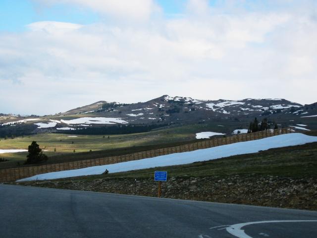
Continuing east on 16, I crossed into the Big Horn National Forest and
Mountain Range. The fresh scent from the surrounding pine trees filled
my nostrils, and deer were everywhere. US-16 has several gentle sweepers
as you slowly make your way to an elevation of 9673'. At 9600', I was
almost level with the snow capped peaks, and the view was breathtaking.
I continued on US-16 through the mountain range until I reached the town
of Buffalo. I had to hop on the slab in Buffalo, but it wasn't too bad
since most of this area of Wyoming is rural. I took I-90 east to exit
153, where I stopped for gas and water. Then I took US-14 north into
Devils Tower National Park.
Devils Tower is one of our most recognizable landmarks, and our first
national monument. Indian legend says that Devils Tower got it's
unique markings when seven young women were being chased by a bear.
They called out for help, and one of the spirits raised the ground
they were standing on to take them out of harms way. As the ground
rose, the bear clawed at the peak, dragging it's nails into the earth,
thus creating the distinctive ridges which surround the tower.
Devils Tower is also recognizable from the movie Close Encounters
of the Third Kind. It was the meeting place where the aliens landed
to meet with us. No matter how hard I looked, I couldn't find Richard
Dreyfuss anywhere.. :-(
Maybe he was hiding out with Jodie Foster??
I paid the $3 admission, and played tourist.
200 yards into the park there was a field filled with little holes and
several cars were stopped. Being the eternally curious sort, I stopped too
and quickly noticed several prairie dogs standing
up from their holes. Many were just sitting, begging for food. I asked a
ranger if I could play "Whack-A-Mole,"
but he just threatened to throw me out of the park. Some people have no
sense of humour.
I rode around to the forbidden side of Devils Tower, and searched in
vain for the secret
military base. I was denied in Roswell, and once again I was denied any
chance to see the aliens from Planet
X.
After leaving the park, I headed south-east on 14 until I came into the
town of Sundance. Sundance, WY is not the same Sundance that is famous
for the indy films, and it's better left undescribed..
Knowing my plan was to arrive in Custer, I hit the slab once again. If
you're on a bike, and you're in south-western South Dakota, there's a
place you have to visit, and I was on my way there. 35 minutes later,
and I was in Sturgis.
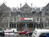
I stopped in the Sturgis Motorcycle Museum, and took some photos. I
asked if they had any postcards in their gift shop, but they reacted as
if I was saying, "Mmmphf booklesplat smeagle," and then directed me
to a gift shop down the road. You'd think that the Sturgis Motorcycle
Museum would have had postcards...
After taking care of the postcard business, I took 385 south. My plan
was to ride it all the way into Custer, but I was to be denied this
simple wish. You see, it had been awhile since my nemesis had plagued
me, and this time 'road work ahead' really had it in for me. Instead
of 385, I was directed to take an alternate route (85) into the town of
Lead, home of the Gold-Diggers. In Lead, I was directed to a dirt road
which stretched 7 miles until it finally arrived back on 385, about
10 miles south of where I started.
Actually, the detour was quite scenic. It took me through a small
valley with a pretty cottage, and a stream running right down the
middle. Hey, I was in Ponderosa!!
I think I see Hos over there!
(an aside) Why is the school mascot for Lead, SD the "Gold Diggers"?
Didn't they ever think it through? "And everyone, let's welcome YOUR
GOLD DIGGER CHEERLEADERS!" (yeah, great one guys).
Back on 385 south, I debated about whether or not I would stop to see
Mt. Rushmore now, or wait until
later. I decided it would be better to head into Custer and check in
for the national, rather than potentially missing the group dinner.
About 15 miles from Custer, I was once again struck by my arch-nemesis,
and was held up in traffic. This time there was some lady from Polk
County slowing traffic down on top of 'road work ahead.' I looked down
at the GPS, and
saw that there was a turn off coming up that would put me right at the
entrance to the American
Presidents Resort, and would most likely take me out of the traffic. I
double checked the route on my AAA map, and it looked good, but I was
really curious what those little
squiggle marks on the GPS meant...
I took 87 from 385 south to the entrance to Custer State Park, then
hopped onto 89. 89 took me right into 16-A, and right next to the
entrance to the American Presidents. So, that was my introduction
to "Needles Highway"
in the Black Hills. What a serious trip that turned into, it's awesome.
Forget Deals Gap, this thing has all of the turns, and no damn traffic
to boot. And those squiggle marks, well I've been scouring the GPS
base maps to find more of them!
I checked in at the camp-ground, paid my $12.50 fee, and setup my tent.
About 5 minutes after I finished getting my tent set, some guy on a
completely mud covered SV-650 comes
up and starts talking. He turns out to be Mike, King Kaz, from
North Dakota where he's studying to be an air traffic controller. Hmm,
what is it with people and blue SV-650's that are studying to be air
traffic controllers? (I know two of them now).
We then met up with Dave from Texas, and shot the breeze for awhile.
Eventually it was time to head to the VFW, and away we went. Dinner
was fun, I sat next to Carl
- "I'm on the road for the next five years, and pass the god damned
pepper foo," and everyone had a good time. As soon as dessert was
done, Mike and I split to go see if we could catch Mt. Rushmore at sunset.
I took him on 89, then 87, and showed him the road I had found. He
was giggling like a school-girl on her first date when he was
done riding that road, and to be honest, so was I. It's really a
fun little road.
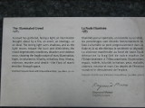
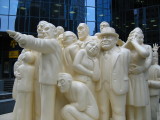
We made it up to Mt. Rushmore, but the monument wasn't lit up and
it was too dark to get any decent photos. So, we decided to head
over to the Crazy Horse Monument, which
was lit up. We arrived at Crazy Horse just as they were closing, but
the attendant let us in to check the site out anyway. We went ahead and
rode up, and I took some photos but unfortunately they didn't come out.
We headed back to the presidents where I was ready for bed. I
went to sleep, and was woken up about 1am my time (I stayed on EST
for the whole trip) by mnrstrider (?) telling me that I was silly
to leave so early because I had won an award at the dinner. He
presented me with my award, "farthest person from home, roughly
1900 miles" which included a $50 gift certificate for Aerostitch.
Thanks! Oh yeah, and at next years meet I'll be presenting a little
token to the winner of the award (and it better not be me), hehheheh.
Total miles: 483/3632
Thursday, June 5th
Being bummed out about the photos from the night before, I really
wanted to get up to Mt. Rushmore and get some pictures in the morning.
I also knew I was planning on heading into Minnesota (Land of Paul
Bunion) that day, so I broke camp then told Mike my plan. I said,
"I'm going to go to Mt. Rushmore and take some photos, I'll be back
in 40 minutes if you want to go riding later."
He was cool with the plan. I headed toward Mt. Rushmore on 385, and
got there in about 15 minutes. I took several photos, then headed back
to Custer; total round-trip time was about 45 minutes.
Mike, Texas Dave, and myself headed over to the "Internet Cafe" where
Dave and I had breakfast. Mike had already filled himself up with
a filling bowl of students
staples (ramen). At breakfast we discussed plans; the weather looked
like it was going to be bad,
so Dave decided to head to Colorado. Mike and I wanted to do the other
half of needles, then hit the badlands,
so that's what we did.
We headed back up 89 to 87, then took 87 south. We had to pay our
$5 entrance fee, but that was fine. The southern part of 87 is not
as challenging as the northern part, but it was still fun. There are
several switchbacks to keep you interested, and it runs through a pretty
forest filled with tall pines and birch trees.
In one of the switchbacks I felt this banging on my foot, and realized
I was scraping my pegs
with a fully loaded bike. 87 eventually ends into 16A, which we
followed east to 36, then we took 36 into Hermosa. The route followed
several little valleys, with gently rolling hills and forests. Deer were
everywhere, and it was very relaxing and pretty.
Once we got to Hermosa, our plan was to follow 40 east for a ways, and
then hop onto this road which had no number, but showed up on the AAA
map. We weren't entirely sure if it was going to be a dirt road or not,
but it was a short cut into 44 and would pop us right through
Buffalo Gap
and well on our way into the badlands.
About 5 miles down 40 my arch-nemesis
struck again. Yes, that's right, 'road work ahead' was at it again. We
were stopped for about 5 minutes until we were given the go-ahead.
Half-way through the one-lane road I spotted the turn off on the
left. Sure enough, it was dirt, but it looked like it was hard packed
enough that it would be manageable. I looked at Mike, and he gave me
the thumbs up, so off we went.
The road headed north for a mile or so, then veered east. It was packed
well enough at the beginning that we were able to make reasonable time
(~40mph). About 15 miles into the road though, the gravel was loose and
the rear end of my bike was getting a little
squirrelly. Not to be one bothered by trivial details like having
my rear-end slide out from under me, I kept trekking on, and eventually
we came to a junction which had the road I was looking for. We headed
due north, and about 10 miles later we emerged on Hwy 44, a bit dustier
for sure, but safe and sound.
We took 44 through the Badlands National Park to Cedar Pass. At Cedar
Pass we each paid our $5 entrance fee, then stopped at a little cafe.
The weather was looking really rough, and I really hoped to make Minnesota
by nightfall, so we agreed to split up. I wished Kaz a good ride, and
thanked him for the trip, then we each went our seperate ways. I headed
North-East on 240, but didn't get more than 5 miles away when the rain
finally caught up with me in Cactus Flats.
In the process of putting my rain jacket on, the plastic holder for my
chatterbox broke;
no more tunes on this trip for me, but this really just emphasized what
a poor design the chatterbox is...
I continued north on 240 to I-90, then headed east on I-90 for 12 miles
to route 73. I headed north on 73 into the town of Philip, where I
got gas and water, then proceeded east on US-14 towards Minnesota.
This area of South Dakota was really empty. Grass prairies spread out
in front of me as far as the eye could see. There were several cows,
but not much else. About a hundred miles from Philip I arrived in
Pierre, which was a medium sized city (probably population 100,000).
Between Philip and Pierre I was able to escape the storm, and most of
that stretch of road was done in the sun.
After a quick stop for lunch, I
left Pierre and continued east on US-14. The area is dotted with large
farms, and not much else. Visions of the Stephen King movie,
Children of the Corn, flooded my head as I passed
several of these farms. Would one of these farms hold a Malachai?
Eventually I started seeing signs on US-14 proclaiming it as the
"Laura
Ingalls Wilder Memorial Highway" -- Laura Ingalls?? Like
the "Little House on the Prairie"
Laura Ingalls??
Sure enough, when I arrived in the town of De Smet I saw signs proudly
describing De Smet as the "Little Town on the Prairie." I always
thought she was from Westville,
Florida.. I wondered if this is where
Nellie Oleson was from too.
Well, the rain started to catch me again, so I stopped at one of the
many road-side parks and donned my rain gear again. Although it looked
really bad with lightning and thunder crashing around me every which way
I could imagine, I never saw more than 10 minutes of rain before reaching
Minnesota.
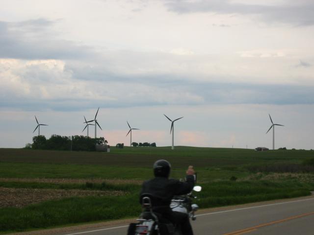
Just before I reached Minnesota I caught up to two other bikers on Harleys. I waved
as I passed them, and continued on. When I crossed into Minnesota I
noticed windmills everywhere,
and stopped to photograph several outside of Lake Benton. As
I was taking the pictures, the group passed me again and I inadvertantly
got a
pretty good shot of one of them waving (or giving me the bird??).
I continued on US-14 into the town of Tyler where I stopped for gas.
There was a little old lady trying to figure out how to fill her car
(apparently it was the first time she ever saw a pay at the pump type
of pump), so I helped her out. She said I had a nice bike and asked
where I was from, then wished me a safe trip as I continued on my way.
After filling up, I headed east on US-14 into the town of Florence,
from there I hopped on MN-23 into Granite Falls where I checked into
a motel for the night. It was starting to get cold, and everything
was wet, so I didn't feel like tenting that night. The last entry in
my journal for that night read, "242 miles to Duluth, 350 to Canada,
and a lake is calling me..."
Total mileage: 572/4204
Posted at: 21:11 on 22/06/2003
[ /travel ]
#
TR and work
I put up part one of my travel report yesterday. Although part two is
written, I need to touch it up a bit before posting it.
Last night Sandy, Geoff, Kathy and I went to the new Cuban restaurant in
town. I was in bed by 9pm, but that was good because I was at work this
morning by 7:45am to swap out network electronics in the 2nd floor closet.
Posted at: 19:07 on 22/06/2003
[ /diary ]
#
Older articles (2026): [ 2002 ] [ 2003 ] [ 2004 ] [ 2005 ] [ 2006 ] [ 2007 ] [ 2008 ] [ 2009 ] [ 2010 ] [ 2011 ] [ 2012 ] [ 2013 ] [ 2014 ] [ 2015 ] [ 2016 ] [ 2017 ] [ 2018 ] [ 2019 ] [ 2020 ] [ 2021 ] [ 2022 ] [ 2023 ] [ 2024 ] [ 2025 ] [ 2026 ]

